I Need Weekly Drone Maps for My Tampa Bay Construction Site - Here's What to Expect
If you're a general contractor or developer running an active construction site in the Tampa Bay area and you need consistent weekly aerial documentation, here's the short version: a FAA Part 107 certified drone pilot flies your site on the same day each week, captures hundreds of high-resolution images, and delivers a 2D orthomosaic map, 3D site model, and progress photos, typically within 48 hours. The cost depends on site size, but monthly retainers for weekly visits start at $1,499 for sites up to 10 acres. Here's how the whole process works from start to finish.
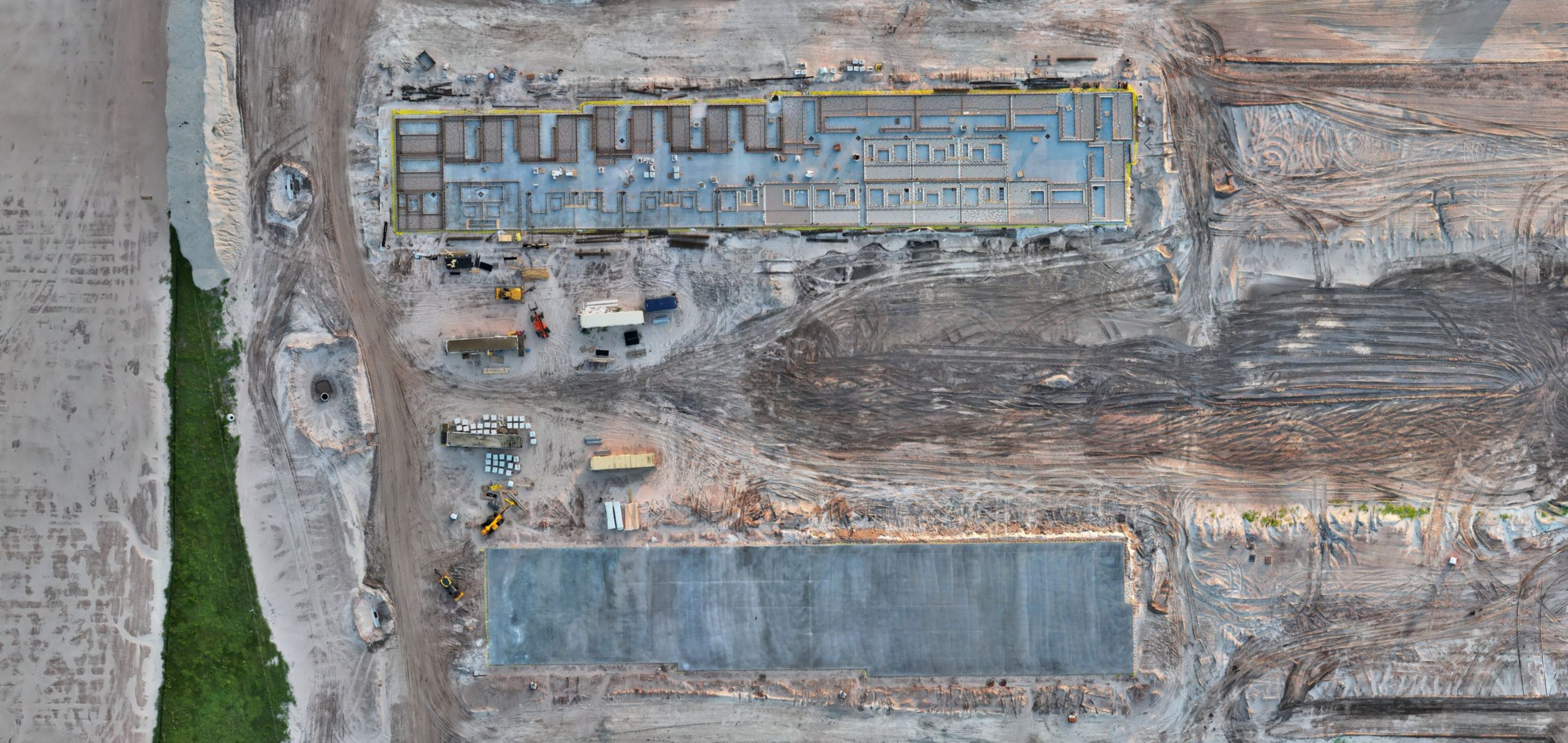
Aerial 2D orthomosaic of a construction site in the Tampa Bay area - captured and processed by RARI Drones with DroneDeploy.
How Does Weekly Drone Mapping Actually Work?
The process is simple and designed to require zero effort from your team on the ground.
We establish a recurring flight schedule on the same day and time each week, so it becomes part of your project rhythm. Before each visit, we check airspace authorization through LAANC, review NOTAMs, and evaluate weather conditions. If conditions aren't safe to fly, we reschedule within 24 hours.
On site, the flight itself typically takes 20 to 45 minutes depending on acreage. The drone flies an automated mission plan at a consistent altitude, capturing overlapping images that get stitched together into one seamless, measurable map of your entire site. We use the same flight plan every week so your maps are directly comparable over time, and you can literally overlay them to see exactly what changed.
What Deliverables Will I Receive Each Week?
Every weekly visit includes the same full set of deliverables:
1. 2D Orthomosaic Map - One high-resolution, geometrically corrected aerial image of your entire site. Every inch captured, measurable, and georeferenced. This isn't a photo stitched together in someone's phone, it's survey-grade aerial data processed through DroneDeploy with sub-centimeter RTK accuracy.
Not sure what an orthomosaic is? Here's a breakdown of what you're getting and why it matters.
2. Interactive Map Link - A shareable link your team, investors, and stakeholders can open in any browser. You can zoom in, measure distances, and compare to previous weeks. No software required.
3. 3D Site Model (if included in your package) - A three-dimensional model of the site generated from oblique aerial imagery. Useful for stakeholder presentations, volumetric analysis, and visualizing vertical progress as structures go up.
4. Progress Photos - Key detail shots of specific areas: foundations, framing, grading, staging areas, and equipment positions.
5. All Source Files Available Upon Request - GeoTIFF, DSM, KMZ, and all raw processed files are available if your team needs them for integration with your own software or surveyor coordination.
3D site model of a Tampa Bay construction site, generated from aerial drone imagery and processed through DroneDeploy.
How Accurate Is the Data?
We fly a DJI Matrice 4TD with RTK connected to the Florida Department of Transportation CORS network. In plain English, our maps achieve sub-centimeter horizontal and vertical accuracy. This is survey-grade data, not a rough estimate from a consumer drone.
All elevation data is processed in NAVD88 US Survey Feet, which matches the same vertical datum your surveyors and engineers are using. Your drone maps and your survey data speak the same language.
What Do General Contractors Actually Use This For?
Weekly aerial maps aren't just nice pictures for your wall. Here's how GCs and developers in Tampa Bay are using them:
Investor and Stakeholder Reporting: Instead of walking an investor around a muddy job site, send them a link to an interactive map showing exactly where the project stands. Weekly comparison maps show clear, visual progress that builds confidence.
Lender Draw Requests: Banks and lenders increasingly want visual documentation to support draw requests. A time-stamped, georeferenced aerial map is more credible than ground-level photos.
Change Order Documentation: When a subcontractor claims work was completed or a dispute arises about site conditions, your weekly maps become a timestamped, objective record that can protect you from costly disputes.
Progress Tracking: Compare this week's map to last week's. See exactly how much grading was completed, where materials moved, and whether work is tracking to schedule. No ambiguity.
Safety and Compliance: Aerial views reveal safety concerns that aren't visible from the ground such as improper material storage, erosion control failures, and unauthorized access points.
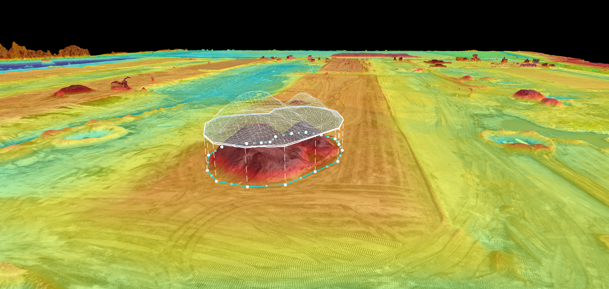
Elevation mapping with stockpile volume measurement. Color-coded terrain data from a construction site.
How Much Does Weekly Drone Mapping Cost in Tampa Bay?
Pricing depends on site size and deliverable package. Here's a general framework for Tampa Bay:
2D Mapping (Ortho + Interactive Map + Progress Photos + All Files):
Up to 10 acres: $1,499/month
10–25 acres: $2,199/month
25–50 acres: $2,999/month
50+ acres: Custom quote
3D Site Model (Everything in 2D + Dedicated Oblique Mission + True 3D):
Up to 10 acres: $2,299/month
10–25 acres: $3,499/month
25–50 acres: $4,499/month
50+ acres: Custom quote
Monthly retainers include weekly visits. Most months that's 4 visits, but months with 5 weeks include 5 visits at no extra charge. That's roughly 1.5 free visits compared to paying per visit, and over a year you get approximately 12 additional visits included.
One-time flyovers are also available if you need a single map, rather than ongoing documentation.
Can I See a Sample Before I Commit?
Yes. We offer a free consultation where we walk you through sample deliverables from previous projects so you can see exactly what you'll receive. We can also discuss a one-time trial flyover of your site so you can evaluate the data quality before committing to a monthly retainer.
What About Bad Weather or No-Fly Days?
Florida weather is unpredictable, we get it. If conditions prevent a safe flight on your scheduled day (rain, high winds, or temporary flight restrictions), we reschedule within 24 hours. You never lose a visit. Safety comes first, and we will never fly in conditions that compromise data quality or risk equipment over your site.
How Is This Different from Hiring a Photographer with a Drone?
A photographer with a drone gives you pretty pictures. We give you measurable, georeferenced, survey-grade data processed through professional photogrammetry software.
The difference matters when your investor asks "how many cubic yards of fill were moved this week" or when a subcontractor disputes a change order. A photograph can't answer those questions. An orthomosaic with RTK accuracy can.
We also bring 15+ years of thermal imaging experience from a career in fire rescue, which means if your project ever needs thermal documentation, we handle that too.
What Areas Do You Cover?
RARI Drones serves construction sites across the Tampa Bay region, including Hillsborough, Pinellas, Pasco, Hernando, and Manatee counties. We're based in Pasco County and most job sites are within 30 to 45 minutes. Sites outside our core service area? We still fly, just reach out and we'll work out the details.
How Do I Get Started?
Three steps:
1. Contact us for a free consultation. Tell us about your project including site location, acreage, timeline, and what you need documented.
2. We'll visit the site and establish the flight plan. Once the plan is locked, it stays consistent every week.
3. Weekly flights begin. Same day, same time, deliverables in your inbox within 48 hours.
Ready to see what weekly aerial documentation can do for your project?